Elsfield’s location
Elsfield is a parish of 1296 acres lying about 3 miles North-East of Oxford. The village lies at the centre of the parish with the western side taking in part of the river Cherwell, and it is here that the outlying Sescut Farm is situated. In 1957 the Victoria County Histories describes the geographical position of Elsfield village thus:
The cottages and farm-houses of Elsfield form a single gently descending street, with the manor-house halfway down and the church, the vicarage and the thatched school house at the bottom. The street runs at a height of about three hundred feet above sea-level, along a spur of the hills which circle round from Beckley and Stowood to Forest Hill and Shotover.
The school house was demolished in the 1960s but otherwise the description still stands. Clark points out that the village is not there by accident. It is a springline village. Rain falls on the areas of Corallian sands and emerges as a series of springs called ‘welle’ in Old English, at the junction with the Oxford clay, thus giving a reliable source of water. The term ‘welle’ still survives in the field name ‘Lockwell’, now ‘Lockels’ and Pennywell Wood. The lower fields in the clay drained by the Bayswater Brook, parts of which are also known as the Washbrook, are often waterlogged in winter, but the higher parts drain well.
There was also a source of stone for building – an outcrop of Wheatley limestone, which was exploited in the 13th century and sold to Merton College for building its library. There is an entry in the Bursar’s Rolls of Merton College dated 1373-6 referring to Elsfield stone:’“Item pro lapidibus emptis apud Elsefelde, 10s.” (“Item for stones bought in Elsfield, 10 shillings”) and the stone was used on the south side of Merton library, which was built 1371-9. There were and still are several wooded areas, which in the past would have been exploited for kindling and pannage (letting pigs loose to forage for food).
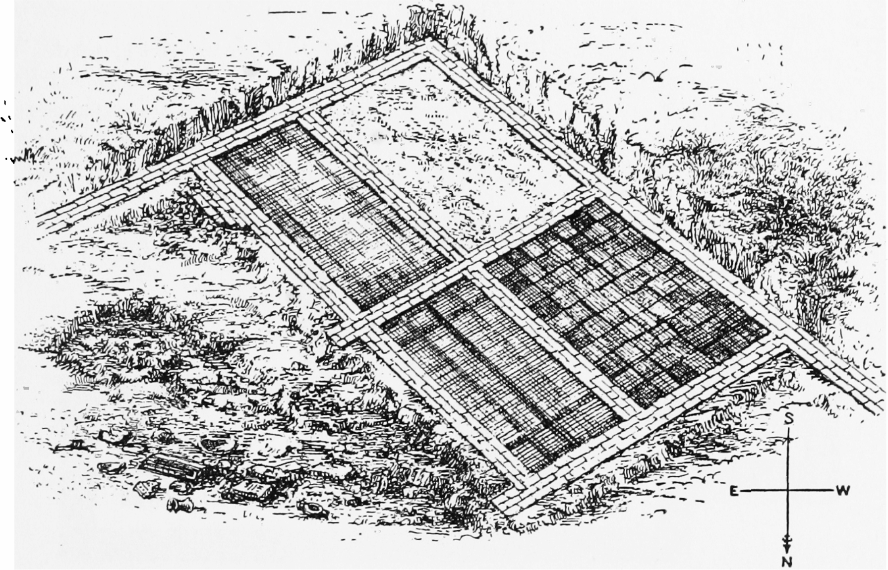
Romans
Although there are substantial Roman remains in the vicinity of Elsfield, the nearest being a smelting furnace at Drun Hill, just outside the parish, a temple complex at Woodeaton, a road passing to the east of Oxford and crossing Otmoor, via Beckley, there appear to be no Roman remains in the village itself or if there are, they have not been found.
More information about the Roman villa near Wick Farm can be found on the Headington website .
A descriptions of the villa can be found in the book “A History of the County of Oxford: Volume 1”. The book is available on the British History online website. This page covers the Roman remains in the Oxford area. See no 24 for the Villa at Wick Farm.
Anglo-Saxons
The name Elsfield is very likely to be Anglo-Saxon, of a standard form: a person’s name: Elle followed by ‘field’. The village is called Esefelde in Domesday. ‘feld’ was probably a term given by Anglo-Saxons to rough pasture, rather than the modern idea of cultivated enclosed land. The term distinguished it from forest, marsh or hilly land, though Elsfield village is approached via a substantial hill. After the Norman Conquest, the land was granted to Robert D’Oyley, but was actually in the hands of Turstin, another Norman, who probably lived at Water Stratford in Buckinghamshire. In the Domesday Book, Elsfield was assessed for taxation at five hides[1]. There was arable land for eight ploughs and in the demesne, the land kept for himself by Turstin, there were five ploughs.
There was a wood three furlongs long by three wide and 29 inhabitants listed: five slaves, eleven villeins[2], seven bordars and six others. This is not to say that this is all the people there were in the village. Women and children would not have been counted, and Clark estimates there were probably about a hundred people living here. He says, “At the time of the conquest Elsfield was worth £4 a year which had risen to £5 at the time of Domesday, the increase in value perhaps attributable to clearing of parts of the forest.”
[1] A hide was approximately 120 acres.
[2] Villeins rented small houses with or without land from the lord. They were expected to work on the lord’s land. In the social pecking order they were above slaves but below freemen. (Wikipedia) Bordars were villeins who rendered menial services to the lord as rent for their cottage.
13th Century
By the 13th century, the two- or three-field system of agriculture was in common use and the method of ploughing has left indications in the landscape which in some cases can still be discerned today. The unit of cultivation was the strip, called a land, roughly 7 by 180 metres (8 by 200 yards or 0.13 hectares). The strips were ploughed in such a way that they earth was heaped up into a ridge of on average a foot high in the centre, with sloping sides which aided drainage. The movement of the plough caused a small amount of soil to be pushed in front of it, making a raised part at the end of the strip when the plough was turned round. Over the years with repeated ploughing these became a substantial feature of the lands and were called heads or butts. The line the plough took was not straight but had a slight reverse elongated ‘S’ curve in it. This was because the plough needed a team of six or eight oxen to pull it. They were yoked in pairs to the plough and took up a great deal of space. If each ridge and strip had been ploughed in a straight line, when the team turned at the end of the ridge, they would have trampled on adjoining strips and ridges. When the plough itself had reached the end of the strip the plough team would have been stretched across the adjoining strips and ridges. By ploughing in a slight ‘S’ shape half the plough team could start to plough by standing on the headland at right angles to the line they were going to follow. These elongated ‘S’ shapes, or sometimes shallow ‘C’ curves, can still be seen even if the ridge and furrow patterns have disappeared because when the land was enclosed in later centuries the hedge enclosing the field followed the line of the medieval ploughing.
People farmed strips in different parts of the parish so the poor and better land was distributed fairly and the strips were banded together to form furlongs, which when it referred to agricultural land was not so much a measurement of length, but of area. The furlong was the unit which determined the kind of use the land was put to: fallow, arable, legumes or grass. Each furlong had a name. Triangular shapes of land which occurred occasionally were called gores.
As well as strips of land to be cultivated each tenant had rights on the common land: to graze animals and cut hay from the common meadows. Most of the work would be jointly organised and carried out, though the animals and corn and hay would belong to the individual tenants.
The furlongs were grouped into two or three large fields and from his reading of original documents Clark suggests there were two fields at one time, the North field and the South field, but then later finds evidence that there may have been three.
An examination of the Cartularies of the Monastery of St Frideswide, which are now available on line show that in one particular charter, dated 1273 there is an agreement by Stephen le Dispenser to give 10 acres of his land in Elsfield to the monastery. Fortunately for us, the land is in very small parcels, mostly half an acre, and are spread about in the parish. He locates them by naming both the furlong and some of the people who own adjoining strips of land. Unfortunately, we do not know where those furlongs were, though we can make a guess at some of them.
Stephen describes his land as:
Half an acre lies against le Wedho
Half acre in Mesforlonge between the land of John atte Twychen and the land of William Coyn
Half an acre in the said forlonge next to the Porteweye
Half an acre in the furlong above in Northfelde which extends to Buryforlonge
1 rod higher in Northefelde
A furlonge near the Portehegge
1 rod in le Hangynde next to the land of John Phillips
Half an acre below Hangynde land next to the land of Robert the Wise
Half an acre which is called Forthshterre in Holdern forlonge next to the land of the said Robert the Wise
Half an acre in Mersforlonge in South field next to the land of William Coyn
Half an acre in the same furlong by Strauputtes next to the land of Roger Goderiche
Half an acre in Thornbreche next to the Greneweye which lies next to the land of Robert the Wise
Half an acre in the Hechjuge next to the land of Roger Godriche
Half an acre which extends in Hedenbrok next to the land of William Coyn
Half an acre Medlond below Haselyngrove
Half an acre above Vivarium ( warren or fishpool) in Eldindone next to the land of John Phillips
Half an acre in Okris next to the land of Roger Godriche
Half an acre in Thornebreche next to the land of William Finemore
Half an acre in Ferniforlonge next to the land of Robert the Wise
Half an acre in Northefelde in Thedede Clay next to the land of the said Robert Goderiche
Half an acre in Brocforlonge next to the land of William de Cimiterio
Stephen agrees to pay 8d at Michaelmas and Lady Day to the Monastery, presumably the income from the ten acres he has given.
Some of these names are completely unintelligible to the modern eye uneducated in Anglo-Saxon: le Wedho, Forshterre, Hechjuge, Okris, Thedede Clay. Others are identifiable from the 1703 map and even from the 2007 map of the Brown family who now farm the land. Le hangynde is the modern ‘Hangers’, Portway is the name of a field lying next to the road on the 1703 map, Portehegge implies this furlong is hedged and by the road, Grenewye may have been the road to Woodeaton, which would have been green in summer though swamped and soggy in winter. Thornbreche and Brocforlonge had been fairly recently taken from the forest, as ‘breche and ‘broc’ signify newly cultivated land. Mersforlonge, ‘marshy furlong’ must have been on low-lying land while Vivarium refers to a warren or fish pond. On the 1703 map there is a field called ‘Fishpool leys’ which lies next to what is now Lousy Mead, and was called Mereleys in 1921, with ‘mere’ meaning ‘pool’ in Anglo-Saxon. Where the Warren is we do not know but Haselyngrove and Buryforlonge imply the proximity of woodland, if ‘bury’ refers to berries, while Hedenbroke may well be the stream which delineates the boundary between Elsfield and Headington now called Bayswater Brook.
There are two geographical references: Northfield and Southfield and these must be the two fields cultivated in the twofield system, and George Clark does not say they were organised into a three field system until 1369. Generally there was a change from a two- to a three- field system during the 12th and 13th century because of the increase in population. Under the three-field system only a third of the land lay fallow while under the two-field system half the land was under cultivation while half was fallow.
There may be signs of this medieval system of cultivation on the present day OS map of Elsfield. The line of the footpath to the east of Forest Farm, for instance, has a distinct ‘S’ shape, as has the field boundary which continues the line of Pennywell Wood to the north-west. The field contiguous to the Elsfield boundary on Wadley Hill farm has a ‘C’ shaped curve while the northern edge of Woodeaton Wood again shows the elongated ‘S’ shape. However, to be absolutely sure that the curves are caused by medieval ploughing, ideally there would be two sides of a field with parallel ‘S’ curves and this is not the case.
In 1279, commissioners drew up the Hundred Rolls which reported that arable, meadow and pasture had greatly increased since Domesday. In Elsfield, in place of the seven villeins there were now eight, but the number of cottagers had increased to 24. Tenants paid money rent or worked the lord’s will from St John Baptist’s Day (24th June) to Michaelmas (29th September). Cottars paid a rent or worked according to the terms of their tenure. All of them had to give one quarter and five bushels of nuts at Michaelmas to the lord of the manor. Several had names which suggest occupations other than general farming: Henry the Smith, Richard the Woodward, Robert the Cooper, William the Miller, who was presumably living at the mill at Sescut. (Sescut means “cottages by the south elder tree”, ‘cot’ usually referring to a humble dwelling, and records suggest that at this time Sescut was more or less cut off from the rest of Elsfield by marsh. The mill had been in existence in the 12th century and was pulled down about 1700 when a farmhouse was built in its place.)
14th Century
In 1327, Gilbert de Elsfield, who died in 1397, applied for a royal licence to ‘impark’ his wood at Elsfield which would give him the right to protect young trees from grazing animals and also to preserve his own deer. There is no written record to show that he actually did this but Cole concludes that the purlieu was made between Woodeaton and Elsfield running from the Islip road to the Cherwell, i.e. along the northern boundary of the parish. Gilbert also obtained a grant of free warren which gave him the right to hunt small game such as roe deer, rabbits, pheasant and duck.
1348 saw the arrival of the Black Death in England. It raged for two years and wiped out a large percentage of the population. This had an important effect on the land. Because there were fewer people to cultivate the soil, much of it was turned over to pasture. Farmers learned an important lesson from this: the importance of leys. This is arable land which is put to grass for short or longer periods and which enables the soil to recover its fertility. There are several leys shown on the 1703 map of the parish, alongside the Woodeaton road.
In 1369, the one hide of land held by the monastery of St Frideswides, which at the time of the dissolution of the monasteries by Henry VIII became Christ Church, was relocated so that they held 74 acres in three equal portions (implying a three-field system). In the parish there were seven acres of meadow, 43 acres of pasture, said to be swamped most of the year, and 36 acres of wood, which was held in common.
In 1363, Elsfield was stated to be out of the Forest, which does not mean that all the trees had been cut down but rather that the Law of the Land applied rather than the Law of the Forest. So Elsfield villagers had no common rights in the forest but they were allowed to pasture their pigs in the king’s woods in and around the village for which they paid twelve shillings per eight pigs. The forest law was not formally abolished until the reign of Charles I, and at that time Elsfield commoners were granted land as compensation for the loss of their rights. They received twenty acres of Forest Farm, which was outside the parish and remained so until 1991.
Gilbert de Elsfield, who sought to empark his wood, was the last man of his line, but his daughter Anne left a daughter Joan, who in 1407 married John Hore of Childerley in Cambridgeshire. Several generations later a daughter, called either Edith or Eliza, married as her second husband Rowland Pudsey, whose descendants were lords of the Manor until 1692.
16th Century
The 16th century saw land being enclosed to graze sheep but there is no record of what happened in Elsfield. In 1516, Henry Wilmot converted 36 acres of arable land to pasture but this was a minor matter. Two inventories of Elsfield men called Day were compiled in 1589. Neither had any sheep. John Day had 17 beasts, three horses and a colt, seven hogs and seven stores (i.e. lean pigs for fattening), twenty capons, cocks and hens. Richard Day, a much poorer man, had only three kine, three bullocks and a calf.